Every Sacred Site on earth can be specifically located with its GPS coordinates. The site may be an earth formation or a human creation either placed on the earth surface or some sort of human created inscription on the rock surface. Earth and meaning giving are entwined.
Jeffers Petroglyphs site is an example. It is on the crest of a ridge of sandstone known as Red Rock Ridge. The name given to the rock is Sioux Quartzite. The rock was originally deposited as red sand and mud during the Proterozoic Period. It is sandstone cemented with silicon dioxide and re-crystalized by heat, pressure and chemical solutions.
The site also has wave marks from ancient Proterozoic shorelines nearly 500,000,000 years ago. There are also scratches (striations) from the Des Moines ice lobe of the Wisconsin Glacier some 12 to 14 thousand years ago. The glacial ice was about a mile thick at the time.
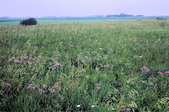
The Little Cottonwood River is about 300 yards to the southeast. Remains of a true tall grass prairie are nearby. The site is located 5 miles east and 3 miles north of the town of Jeffers in north-central Cottonwood County of Minnesota, USA.
Tuesday, December 18, 2007
Wednesday, December 12, 2007
The Rising Up of Bear Butte as a Sacred Site
Bear Butte, just east of the Black Hills of South Dakota, USA, rises from the prairie and dominates the horizon. From the peak one can view the hills and the prairie. As a sacred site of the Native American heritage Bear Butte is known as sacred because it figures large in the culture of a people. On Bear Butte prayer flags decorate the trail leading up, around and to the top. One ascends into a unique realm of sky, earth, east, west, north, south uninterrupted. Centuries of experience have given an atmosphere of mystery and grandeur to a natural place. So we call it a Sacred Site.
Jeffers Petroglyphs are on the flat landscape. No grand views. They too rise up as a Sacred Site. Glyphs are created by people to give meaning to life and to communicate with future peoples. Getting in touch with what is being transmitted is one purpose of this study of sacred time and places in the 21st century.
Jeffers Petroglyphs are on the flat landscape. No grand views. They too rise up as a Sacred Site. Glyphs are created by people to give meaning to life and to communicate with future peoples. Getting in touch with what is being transmitted is one purpose of this study of sacred time and places in the 21st century.
Wednesday, December 5, 2007
Cottonwood County, Minnesota, USA
The Jeffers Petroglyph's are located in what is now called Cottonwood County, Minnesota. Records show that the county was first surveyed in the late 1850s. The County was organized July 29, 1870. Three county commissioners were appointed by Governor Austin. The commissioners first met a private home. They designated districts and agreed on officials. The first formal election was in the fall of 1870. The first property deed was filed January 10, 1870 and first taxes paid in 1871. The Petroglyph's are located in Section 9 of Delton Township near the Little Cottonwood River.
What was the location called when the Petroglyph's were created? No one knows just which group of early nomadic people created the symbols now found engraved in Quartzite. There is speculation that in the Prairie Archaic Tradition (5,500 to 3,000 BCE) the region was covered with grassland and that hunting bands camped at various favored localities providing wood, water, and food resources.
In the Modern Period (1650 -1850 CE) the site was likely occupied by the Dakota but it is known that Arapaho, Cheyenne, Foxes, Iowa, Missouri, Ojibwe, Omaha, Oto, Ottawa, Ponca, Sauk, Winnebago, and Wyandot were present in Minnesota at this time.
Whatever the area has been named over the centuries and millenia, the Petroglyph's continue to define a people who were given to finding meaning in their time and to communicating that meaning with succeeding peoples.
Information sources include: http://co.cottonwood.mn.us/aboutus.html
http://www.thudscave.com/petroglyphs/arch-peop.htm and references to "The Jeffers Petroglyph Site: A Survey and Analysis of the Carvings" by Gordon Lothson 1976.
Subscribe to:
Posts (Atom)