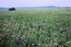
The Jeffers Petroglyph's are located in what is now called Cottonwood County, Minnesota. Records show that the county was first surveyed in the late 1850s. The County was organized July 29, 1870. Three county commissioners were appointed by Governor Austin. The commissioners first met a private home. They designated districts and agreed on officials. The first formal election was in the fall of 1870. The first property deed was filed January 10, 1870 and first taxes paid in 1871. The Petroglyph's are located in Section 9 of Delton Township near the Little Cottonwood River.
What was the location called when the Petroglyph's were created? No one knows just which group of early nomadic people created the symbols now found engraved in Quartzite. There is speculation that in the Prairie Archaic Tradition (5,500 to 3,000 BCE) the region was covered with grassland and that hunting bands camped at various favored localities providing wood, water, and food resources.
In the Modern Period (1650 -1850 CE) the site was likely occupied by the Dakota but it is known that Arapaho, Cheyenne, Foxes, Iowa, Missouri, Ojibwe, Omaha, Oto, Ottawa, Ponca, Sauk, Winnebago, and Wyandot were present in Minnesota at this time.
Whatever the area has been named over the centuries and millenia, the Petroglyph's continue to define a people who were given to finding meaning in their time and to communicating that meaning with succeeding peoples.
Information sources include: http://co.cottonwood.mn.us/aboutus.html
http://www.thudscave.com/petroglyphs/arch-peop.htm and references to "The Jeffers Petroglyph Site: A Survey and Analysis of the Carvings" by Gordon Lothson 1976.
Subscribe to:
Post Comments (Atom)


No comments:
Post a Comment